Water Has a Memory: Preserving Strawbery Banke Museum from Sea Level Rise
By Rodney Rowland, Director of Facilities and Environmental Sustainability, Strawbery Banke Museum
Strawbery Banke Museum’s historic houses – some of Portsmouth’s most priceless heritage -- are being damaged by the impact of sea level rise. Right now. As preservationists, Strawbery Banke Museum must find solutions to meet the threat. Strawbery Banke and the City of Portsmouth, with many others, are taking action before it’s too late.
Surface Flooding & Groundwater – What Lies Beneath
Sea level rise is dramatically visible in areas all over the world and as seen on the news almost weekly. While major cities like London and Tokyo have invested in massive projects including flood gates and reservoirs, the water rises in Portsmouth, New Hampshire.
When it comes to visible flooding in the historic Portsmouth neighborhood where the museum is located, and along the Seacoast, there are two types of flooding, neither of which is a measure of sea level rise. There is surface water that collects in puddles during storms. And there is groundwater, the unseen water table, below ground. At Strawbery Banke, groundwater is also affected by the twice-daily tides when water returns to the tidal inlet that was filled-in around 1903.
Both types of flooding are aggravated when extra-high tides (king tides) and storm surges raise the local tide heights by extra feet. Put them together and there’s severe flooding along the Seacoast.
Strawbery Banke is further concerned about what will happen as sea level continue to increase, as modeling done by the City predicts.
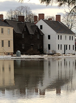
Puddle Dock, the former tidal inlet at the heart of the Strawbery Banke Museum campus, fills with water when rainwater puddles and snowmelt combine with groundwater. Credit: Strawbery Banke Museum.
The Impact on Portsmouth
King Tides and storm surges have brought the future to the doorstep on the New Hampshire Seacoast.
But a significant amount of the most urgent evidence is hidden out of sight. Walk across the green lawn at the center of the museum’s 10-acre campus and you’re walking a few feet above the tide. The groundwater, in places, just under 3 feet beneath the surface, on a sunny day. Add the height of a full moon tide, a storm surge or – by 2050 an additional 1.0 to 1.7 feet from sea level rise, and as much as 6.3 feet by 2100 – and the water rises through the cellar floors of Strawbery Banke’s historic houses bordering that filled inlet: Shapley Drisco House (circa 1795), Lowd House (circa 1790), Jones House (circa 1790) and Sherburne House (circa 1695). And the rising waters are taking foundations, house post beams and the evidence of human settlement with it.
Now Strawbery Banke, one of the most at-risk sites in Portsmouth, is testing ways to protect the historic houses, their contents and archaeological evidence underground from further damage.
Preserving Strawbery Banke
Why is Strawbery Banke Museum -- a history, education and discovery place -- involved in this effort?
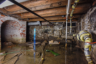
The dirt floor basement of the c. 1795 Shapley-Drisco House fills with up to 18” of brackish water when full moon tides and storm surges raise the level of groundwater beneath the house. Credit: David J. Murray/ClearEyePhoto.com
The answer is shown dramatically in a time-lapse video of groundwater rising through the dirt floors of one of the most historic buildings on Puddle Dock. During King Tides and nor’easters, 16 to 27? of salt water floods this cellar along resulting in crumbling brick and foundation walls dissolved by the salt. In addition, the relative humidity inside the house that results from all this water measures between 80 and 90 percent during 6 months of the year (Curran, B., Routhier, M., and Mulukutla, G. (2016). Sea-Level Rise Vulnerability Assessment of Coastal Resources in New Hampshire. APT Bulletin – Journal of Preservation Technology. Special Issue on Climate Change and Preservation Technology. Volume 47 (1), 23-30.), which causes irreversible harm to the building and the decorative arts collection displayed at this site.
The museum first confronted the damage from groundwater during preservation efforts in Lowd House. The brick foundation was deteriorating. A difficult decision arose: save the original basement “summer” kitchen and the brick hearth built in 1810, or save the chimney and house frame it supported? The basement hearth is now gone. Replaced with granite that will prevent sea water from wicking up the remaining brickwork. What other history will be lost to save what can still be saved?
Addressing the Damage to Historic Houses
In the summer of 2018, surface flooding from a heavy downpour topped the bulkhead in Jones House, sending a waterfall pouring into the cellar. Again, preservation of a part of the structure – the historically accurate position of the bulkhead – had to be sacrificed for the whole. A new bulkhead, raised 18 inches above ground-level, replaced the old and saved the 1790 foundation and cellar of Jones House from further damage.
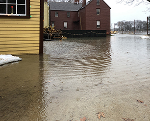
Heavy rains and runoff – Strawbery Banke is one of the lowest points in the City – soon overpowered the storm drain. Credit: Rodney Rowland/Strawbery Banke Museum.
In December 2019, heavy rain, snow melt and a King Tide created a “lake” on Puddle Lane. Instead of directing the flood water into the stormwater pipes that stretch through Puddle Dock to the river, the storm drain overflowed. Strawbery Banke and the City Department of Public Works Water Division are investigating options and considering solutions like a rain garden to prevent further erosion and damage to the neighboring buildings.
But water has a memory and the seas still rise.
Measuring Impacts. Collaborating on Solutions
In 2011, Strawbery Banke was chosen to be a test site for a City of Portsmouth, University of New Hampshire and Rockingham Planning Commission study to assess sea-level rise vulnerability of coastal resources. The report provides the starting point for understanding the impacts of climate change and possible adaptation measures that the City can take over time to protect private property like Strawbery Banke and public infrastructure maintained by the City Department of Public Works Water Division.
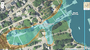
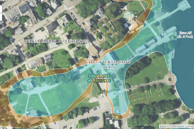
City of Portsmouth Climate Change Vulnerability Assessment maps show the impact of sea level rise flooding on Portsmouth’s historic waterfront, including Strawbery Banke Museum. Credit: City of Portsmouth NH.
In 2013, the museum joined the City of Portsmouth’s Local Advisory Committee (LAC) for the Climate Change Vulnerability Assessment on Historic Portsmouth to evaluate the areas most vulnerable to sea level rise and storm surge, based on historic, cultural and property values.
Because Strawbery Banke is one of the lowest points in the city, the flood elevation maps, vulnerability assessments, suggestions for potential adaptation strategies and City recommendations for future planning, regulation and policies all revolve around Strawbery Banke. Which makes the museum a prime platform for informing the public about sea level rise impacts in Portsmouth and other coastal spots.
That’s where a new joint museum-City exhibit, “Water Has a Memory: Preserving Strawbery Banke and Portsmouth” that will open in Fall 2021, along with the continued collection of data come in.
Collecting & Mapping the Data
One project involves placing wells and sensors around the city, including at Puddle Dock. To answer "Where is the water coming from?" the UNH Geospatial Science Center would collect data from six wells to measure water temperature, depth, and salinity. These wells were recommended in the City's 2018 report "Preparing Portsmouth's Historic District for Sea Level Rise."
Strawbery Banke and a growing number of City, County, State, regional and Federal bodies and agencies are working collaboratively to help prepare the community for a future very different from today. All of these organizations including Strawbery Banke are sharing their work in hopes of fostering a dialogue on this important issue. The new exhibit is part of that effort.
Additional public and collaborative initiatives include:
- “Keeping History Above Water” national conferences (2017, 2018, 2019, 2021)
- Rockingham County Planning Commission, High Water Mark Initiative
- ICNet: The Infrastructure & Climate Network (ICNet) is a network of over 60academics, students, and practitioners who are dedicated to accelerating climate science and engineering research in the Northeastern United States
- American Association of State and Local History webinar on museums and climate change and Strawbery Banke AASLH blog
- New England Museum Association, "We Are Still In" webinar
- Sustainable Museums/UN Sustainable Development initiative
- NH Preservation Alliance "Wet Basements" Workshop
- NH Engineering Conference, Concord NH to explore options to ameliorate basement ground water flooding.
- TedX Talk at Eaglebrook School, MA.
- Resilience Symposium for Cultural Institutions (September 2019)
The water is rising; but solutions to the very real sea level rise threatening the future of places that matter, like these, will come from community conversation and cooperation.
It is an open partnership and community awareness and participation will help create the best solutions.
About the Author:
Rodney Rowland, Director of Facilities and Environmental Sustainability, first volunteered for Strawbery Banke in 1976. He is currently responsible for the historic properties on the site, overseeing the properties and restoration department and is project manager for various museum initiatives including the Sea Level Rise Initiative. After graduating from Lake Forest College with a B.A. in history, Rodney interned with the museum, then joined the museum staff in 1990, as curatorial assistant working with the Curator on new exhibits and processing the decorative arts collection. He later became Collections Manager and was lead objects conservator for the 1943 Little Corner Store project. In 2004, Rodney was promoted to manage the construction of the TYCO Visitors Center (2005) and the Carter Collections Center (2008).